


We rely daily on the GPS on our phones to get to many different places in our lives. However, the technology stops working in the depths of the ocean, which is why submarines need something different. That is because satellite signals cannot pass through ocean water efficiently, forcing these underwater vessels to rely on alternative systems in order to navigate.
To steer these submarines, which can stay underwater for months and travel practically blind, one of the main systems used is the Inertial Navigation System (INS). This tool is capable of calculating movement and direction the submarine is headed, without external references to guide the crew. This helps keep routes safe, especially when the ocean blocks most other types of communication.
In addition, the crew also has other ways to figure out where they are. It’s possible to combine these calculations with detailed maps of the ocean’s underwater terrain and other procedures to reduce the chance of error. So, even though they don’t have GPS access like we do on the surface, submarines have other alternatives to not get lost during a mission.
How submarines navigate without GPS underwater

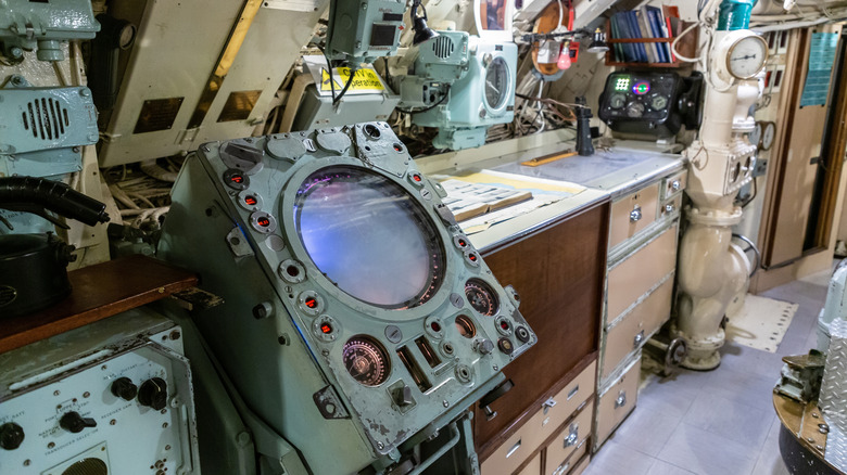
Since GPS does not work underwater, submarines, including advanced nuclear-powered ones, primarily depend on inertial navigation to determine their position in the ocean. This system starts from a known position and, using gyroscopes and accelerometers, determines the direction, speed, and displacement during the journey. It then adds up every change in movement along the route to estimate where it is, but this also creates problems, since small calculation errors can build up, creating a drift.
To reduce these errors and the chances of a submarine getting lost in the open sea, there are other layers of support. One of them is manual dead reckoning, which sailors use as a backup to estimate position based on the submarine’s heading and speed. There are also bathymetric charts, which are detailed maps of the underwater terrain, important for comparing the real environment with what is already known about the seafloor.
In some situations, the submarine can also use sonar or other acoustic methods depending on the mission they are involved in, but with caution. Active sonar, for example, sends out pings that help with navigation, but it can also reveal the vessel’s position to others nearby. Because of that, there are also more discreet solutions, such as terrain-relative navigation, which compares the terrain detected during the mission with other maps in an attempt to correct drift and make journeys more accurate.
Why GPS signals can’t penetrate water
One of the major problems that GPS faces in working underwater lies in the type of signal it uses. Satellites emit radio waves at high frequencies, such as the L-bands used by GPS, but this type of communication quickly loses strength when it tries to penetrate water. Under the sea, this is even worse, since the salt from seawater increases conductivity, causing the signal to be lost almost immediately.
The effect is so severe that a submarine operating at even minimal depths becomes completely isolated from GPS satellites. That’s why, when submerged, they cannot receive location data the same way a phone or a car on the surface can, and this issue affects similar services like GLONASS, Galileo, and China’s advanced GPS alternative BeiDou as well.
For GPS to work properly, the submarine would need to be close to the surface, which isn’t very useful during many missions. There are some extremely low-frequency radio wave alternatives, such as ELF, that are capable of reaching them. However, they are usually so slow that transmitting a three-character-long code can take around 15 minutes, which is far too slow for something that needs to navigate in real time.

")
