


Google is working on several Google Maps features that might benefit navigation modes and experiences that do not involve driving. The latest one is a new setting for walking directions that will help you avoid the sun as much as possible. The feature might come in handy during peak UV hours in the hot summer months. It’s easy to choose a route with more shade if you’re familiar with the city. But the Google Maps feature in testing would also help you find routes with shade in unfamiliar neighborhoods.
Found by Android Authority in the latest version of Google Maps for Android, the “Prefer shade” toggle will be available in the Trip Options menu once Google launches it. Interestingly, the code shows options for walking in the shade and in the sun. An option to choose walking routes in the sun could come in handy in the fall and winter, when you might prefer sunnier routes. Also, the app will tell you how many minutes you’ve spent walking in the sun. That said, there’s only a “Prefer shade” toggle in the Trip Options menu.
Android Authority notes that it’s not clear how Google would tell shady and sunny parts apart, and adds that other apps use LiDAR tech to map routes with shade. On that note, Google Street View cars have LiDAR sensors, which could help with the “Prefer shade” feature. However, since Google Maps is a navigation app, simple algorithms that take into account the time of day, geographical location, and waypoints on a walking navigation route could determine how sunny or shady a street would be at a particular time of day, without accounting for street vegetation that can help improve shade.
Will Google Maps use Project Sunroof tech?
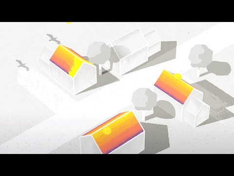
Google already has technology in place that maps sun exposure. Launched in 2015, Project Sunroof is a Google Maps feature that has nothing to do with navigation. Its purpose is to help users decide whether installing solar panels on their roofs is viable. Put differently, Google can use Google Maps data to determine whether your house has good sun exposure. It can use that data to estimate the amount of electricity the solar panels would generate.
The video above explains how the Project Sunroof tech worked a decade ago, well before the age of AI. “We could take the information that’s already in Google Maps and use it to show how much sunlight falls on a roof,” the video explains. “Then we can combine that with all the other stuff people need to figure out and create kind of a treasure map of solar energy.” Google has updated its Solar API in Google Maps since then. The same technology could very well be used to power walking directions in Google Maps that take into account the amount of shade on your journey.
Add all the AI innovations we’ve witnessed in the past three years, including Google’s advanced Gemini models that are available in Google Maps, and Google might supercharge a feature like Project Sunroof with AI and repurpose it for the feature Android Authority discovered. This is all speculation, but the technology Google needs for the feature is already there.


