


Creating professional maps can be frustrating. One tiny miscalculation, and suddenly you’re redrawing half the project—hours of work down the drain. But there’s a nifty solution: AI map generator tools!
With the mapping industry growing at 12.2% a year, it’s no surprise that designers, architects, urban planners, developers, and even hardcore gamers are turning to AI for faster, more accurate custom maps. These tools aren’t just about speed; they’re packed with enterprise-level features (often without the enterprise-level price tag).
Whether you need a fantasy map generator, a world map generator, or something for commercial use, we’ve got you covered. Let’s check out the best AI-powered tools that make mapping easier, smarter, and way less stressful.
Top 8 AI Map Generators to Create Custom Maps with Ease
Here’s a rundown of the best AI map generator tools:
| Tool | Best for | Key features | Pricing |
| Location-specific project workflows | Map View, AI whiteboards with image generation, Custom Fields for geotagging tasks | Free plan available; Customizable paid plans for enterprises | |
| Inkarnate | Fantasy world-builders & tabletop gamers | Asset library, layer editing, brush/mask tools | Free; Pro: $5/month |
| Maptive | Data-rich geographical visualization | Heat maps, territory planning, route optimization | $250/45-day pass; $110–$220/month; Enterprise: Custom |
| Scribble Maps | Educators, event planners, and route designers | Isochrone maps, custom drawing, SHP/KML exports | Free; $19–$100/month; Enterprise: Custom |
| ArcGIS Online | Mapping complex spatial data | Data layering, SQL filters, dot density maps | Custom pricing |
| Google Maps | Developers needing robust mapping integration | API access, geocoding, Street View, live traffic | Free |
| Mapbox | Custom, performance-driven mapping solutions | 3D landmarks, AR readiness, live traffic routing, SDKs/APIs | Free; Pay-as-you-go |
| Kepler.gl | Large-scale location data visualization | Heat/arc maps, data layering, tooltip customization | Free open-source |
What Should You Look for in AI Map Generators?
The best AI world map generators combine machine learning with traditional cartography, making map creation faster and smarter. When choosing an AI map tool for commercial use, here’s what matters most:
- Performance and speed: Time is money, and your AI map generator should accelerate your project management workflows. If precise mapping once took two hours, it should now take minutes
- Innovative customization: The best tools balance control and ease of use. Look for features like terrain modeling, environmental planning, custom color palettes, and style templates to match your project’s needs
- Data visualization tools: Effective maps go beyond aesthetics. Your tool should support heat maps, land use zoning overlays, and infrastructure network visualizations to give deeper insights
- Practical editing features: A great map isn’t just generated—it’s refined. Much like AI for graphic design, tools with drag-and-drop functionality and layer-based editing help you tweak points of interest in just a few clicks
- Real-time collaboration: Sharing is essential if you work with teams across locations. Your AI tool should allow simultaneous edits, link sharing, and easy embedding in presentations
The right AI map generator works with you, not against you. Let’s explore the top tools (including some free AI map generators) that check all these boxes.
👀 Did You Know? With modern AI tools, you can transform your smartphone into a 3D scanner to create detailed floor maps of your home in just minutes. Apps utilizing LiDAR technology generate precise 2D and 3D floor plans, making interior design and room layouts a breeze.
The 8 Best AI Map Generators
Professional mapping needs can differ significantly depending on the industry and project, including considering political boundaries. We’ve rounded up the best AI map generators, each of which excels in its own niche. Knowing what each tool offers will help you find the perfect fit for your workflow.
1. (Best for map creation and streamlining location-specific project workflows)
Let’s start this list with —it redefines how you handle location-based tasks by integrating mapping and project management to simplify visual planning.
Work today is broken. Our projects, knowledge, and communication are scattered across disconnected tools that slow us down. fixes this with the everything app for work, which combines projects, knowledge, and chat in one place—all powered by AI that helps you work faster and smarter.
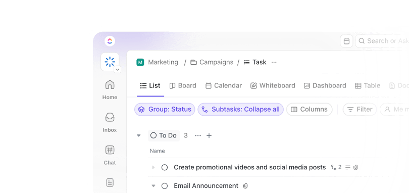
Using the Map View, you can plot the relevant addresses and locations for your Tasks, move tasks around the map to shift their location fields, and filter different projects via regions—all while staying connected to your core project management setup.
Use it to plan service coverage for field teams, optimize delivery routes, or schedule on-site visits. Assign tasks based on region or proximity. And combine location with status, priority, and due dates for a comprehensive view of regional performance.
You can also create a base world or city layout using AI-image generation in Whiteboards. As you define your city’s key landmarks—hospitals, buildings, shops, safe zones—you’ll want to keep track of their real or fictional locations.


Create Tasks in for each location and add an address, coordinates, or descriptive placeholder into the Custom Fields (e.g., “The Red Tower—Sector 3”). Switch to the Map View to see all your key points plotted visually—great for spatial awareness, balance, and planning.
Assign collaborators to tasks tied to each location:
- Level designers for gameplay zones
- Architects for building blueprints
- Planners for utilities or roads
- Writers for lore tied to each area
Use ’s Custom Statuses and Task Priorities to track progress in each area. Jump back to your Whiteboard to sketch new zones, highlight zones under development, and pin images, task links, and docs directly on top of the map. This becomes your real-time command center for visual collaboration.

💡 Pro Tip: Use the Whiteboard as your “master planning board.” Layer ideas, notes, and zones over your AI-generated map like digital sticky notes.
best features
- Track location-specific data with Custom Fields for site measurements, zoning requirements, and environmental factors
- Manage projects from multiple angles using list, board, calendar, and timeline views
- Link tasks to geographic addresses for seamless editing and updates
limitations
- The interface may feel overwhelming at first due to its many features
pricing
free forever
Best for personal use
Free Free
Key Features:
unlimited
Best for small teams
$7 $10
Everything in Free Forever plus:
business
Best for mid-sized teams
$12 $19
Everything in Unlimited, plus:
enterprise
Best for many large teams
Get a custom demo and see how aligns with your goals.
Everything in Business, plus:
* Prices when billed annually
ratings and reviews
- G2: 4.7/5 (10,000+ reviews)
- Capterra: 4.6/5 (4,300+ reviews)
What real-life users are saying about
📮 Insight: 11% of our respondents leverage AI primarily for brainstorming and ideation. But what happens to these brilliant ideas afterward? This is where you need an AI-powered whiteboard, like Whiteboards, which helps you instantly turn ideas from the brainstorming session into tasks.
And if you can’t quite explain a concept, simply ask the AI image generator to create a visual based on your prompt. It’s the everything app for work that enables you to ideate, visualize, and execute faster!
2. Inkarnate (Best for fantasy world-builders and tabletop gamers)
Want to create rich, detailed maps for your next D&D campaign or fantasy world? Inkarnate, an AI fantasy map generator, lets you design immersive environments with a drag-and-drop editor and a vast asset library.
Its innovative blend system allows you to mix styles and assets, bringing sprawling kingdoms, ancient ruins, and mythical creatures to life. Start with a preset, then layer and refine elements as your project evolves.
Your initial style choice isn’t final—you can switch or combine styles anytime, making it easy to craft complex urban layouts or unique fantasy landscapes.
Inkarnate best features
- Collaborate in real time with team members—perfect for group world-building sessions
- Fine-tune details with precise Brush and Mask tools
- Adjust editing resolution to balance quality and performance
- Speed up workflow with keyboard shortcuts and navigation tools
- Organize objects into layers for easier editing and manipulation
- Use a vast library of customizable assets, including terrain, buildings, and vegetation
Inkarnate limitations
- 4K resolution maps have some functionality restrictions
- Object placement tools can be limiting in high-res modes
Inkarnate pricing
- Free forever
- Pro: $5/month
Inkarnate ratings and reviews
- G2: Not enough reviews
- Capterra: Not enough reviews
3. Maptive (Best for data-rich geographical visualization)
Want to turn your location data into actionable insights? Maptive makes it effortless.
Drop your spreadsheet onto Maptive (it works with Excel, Google Sheets, or CSV), and watch your data spring to life on the map. No more manual plotting—every address and coordinate finds its perfect spot automatically.
Maptive’s analysis tools help you spot trends at a glance. You can see where your customers cluster with heat maps, compare location performance using bubble maps, and draw and optimize sales territories in minutes.
Maptive best features
- Generate radius maps to analyze market reach and service areas
- Color-code demographic data to spot customer trends and opportunities
- Plan field team routes with distance and drive-time estimates
- Share maps securely with custom access levels
- Create territories with smart boundary tools for sales planning
Maptive limitations
- Usage limits can restrict projects that require displaying multiple static maps simultaneously
Maptive pricing
- 45-Day Pass: $250
- Pro: $110/month
- Team: $220/month
- Enterprise: Custom pricing
Maptive ratings and reviews
- G2: 4.7/5 (30+ reviews)
- Capterra: Not enough reviews
4. Scribble Maps (Best for educators, event planners, and route designers)
Scribble Maps lets you draw, mark, and highlight maps as naturally as you would with a pen on paper.
Let’s say you want to plan a school field trip to the Natural History Museum. You can draw the walking route from the bus drop-off point, circle the designated lunch area, mark emergency meeting spots, and highlight restricted zones for kids.
It lets you calculate routes between locations, create buffer zones around specific points, and generate travel-time maps (isochrones) to show how far someone can travel within a given timeframe.
Scribble Maps best features
- Switch base maps to find the ideal background for your needs
- Generate custom maps with rich styling options and layered data for clear visuals
- Use advanced spatial tools like routing and isochrones for deeper insights
- Share maps in SHP, KML, GeoJSON formats, or embed them on websites
- Edit maps effortlessly across devices, whether at your desk or in the field
Scribble Maps limitations
- Lacks advanced GIS features, making it less suitable for complex spatial analysis
- The free version lacks premium features like export limitations and fewer customization options
Scribble Maps pricing
- Free forever
- Pro Basic: $19/month
- Pro Business: $100/month
- Enterprise: Custom pricing
Scribble Maps ratings and reviews
- G2: 4.6/5 (190+ reviews)
- Capterra: 4.8/5 (40+ reviews)
What real-life users are saying about Scribble Maps
🧠 Fun Fact: Notorious pirate Bartholomew Sharpe once seized a Spanish ship laden with valuable maps. Recognizing their worth, he commissioned London mapmaker William Hack to create an atlas based on these stolen charts, underscoring the high stakes of cartographic knowledge in the age of exploration.
5. ArcGIS Online (Best for mapping complex spatial data)
You’re analyzing a neighborhood for a new community center. Instead of juggling multiple spreadsheets, you can use ArcGIS Online to layer your data like a cake.
Start with population density (that’s your base layer), add median income (there’s your icing), and end with existing community services (cherry on the top!)
Suddenly, you’re not just looking at numbers—you’re spotting opportunities and gaps.
Use the Scene Viewer to stand virtually on any rooftop and see what’s visible. You’ll know exactly which tables will have the best city views.
ArcGIS Online best features
- Refine data sharing by granting access to specific groups for collaborative updates
- Identify trends faster with clear visual patterns
- Generate interactive dot density maps to highlight population distributions or resource concentrations
- Automate map updates with custom data pipelines that sync with source data
- Leverage SQL expressions for real-time field calculations and dynamic insights
ArcGIS Online limitations
- The lack of group layers makes managing multiple data sets more time-consuming
ArcGIS Online pricing
- Custom pricing based on the type of license you need
ArcGIS Online ratings and reviews
- G2: 4.5/5 (530+ reviews)
- Capterra: 4.5 (500+ reviews)
6. Google Maps (Best for developers needing robust mapping integration)
You rely on Google Maps to get from point A to B, but did you know it also gives you the power to build something way bigger? This isn’t just a navigation tool—it’s a full-blown world map generator hiding in plain sight.
With its powerful API, you can tap into Google’s massive location database and layer in your own data. Developers are getting creative, blending architectural renders with street-view imagery for interactive property tours, using detailed maps, adding custom markers for amenities, and even pulling in real-time transit data.
Basically, if you’ve ever wanted to turn Google Maps into your personal mapping playground, now’s your chance.
Google Maps best features
- Access detailed location data, including reviews, peak hours, and local insights with the Places API
- Add immersive, ground-level perspectives using Street View images
- Stay updated with live traffic, transit schedules, and road closures
- Customize map styles to match your brand while keeping Google Maps’ familiar feel
- Convert addresses to coordinates (and vice versa) with advanced geocoding
Google Maps limitations
- Consumes significant mobile data, especially with features like Street View and live traffic
- Public transit information may display outdated schedules and bus stop locations
Google Maps pricing
Google Maps ratings and reviews
- G2: 4.6/5 (30+ reviews)
- Capterra: 4.7/5 (1,700+ reviews)
What real-life users are saying about Google Maps
💡 Pro Tip: Use custom map styles in combination with data layers to create unique visualizations while maintaining familiar navigation patterns for clients.
7. Mapbox (Best for highly customizable, performance-driven mapping solutions)
Mapbox goes far beyond traditional mapping tools you use for commercial purposes. With its powerful APIs and SDKs, you can build everything from sleek web interfaces to immersive AR experiences.
Whether you’re developing web, mobile, or even automotive applications, Mapbox gives you the tools to make it happen.
What makes it truly powerful is how it handles big data. While other platforms might struggle with massive datasets, Mapbox’s tile set rendering approach keeps everything running smoothly. Load complex data, add interactive elements, and watch as your maps respond instantly.
Mapbox best features
- Customize map styles with templates or create unique designs to fit brand needs
- Enhance maps with dynamic lighting and 3D landmark buildings for immersive experiences
- Leverage global datasets from over half a billion monthly users for accurate insights
- Search precise addresses and points of interest with simple APIs
- Optimize navigation with traffic-aware routing engines in real time
Mapbox limitations
- Advanced customizations require technical expertise, posing a challenge for non-experts
Mapbox pricing
- Free
- Pay-as-you-go pricing structure for monthly requests
Mapbox ratings and reviews
- G2: 4.3/5 (40+ reviews)
- Capterra: 4.5/5 (30+ reviews)
What real-life users are saying about Mapbox
8. Kepler.gl (Best for managing large-scale location data)
Kepler.gl turns raw geospatial info into stunning, interactive maps in minutes.
Just drop in your dataset—GPS coordinates, trip routes, or regional stats—and watch it transform into meaningful visuals. Stack layers like heat maps, arc maps, or point clouds to reveal hidden trends.
Customize colors, apply filters, and fine-tune spatial details to focus on what matters. No matter the data size or format, Kepler.gl helps you make sense of it all.
Kepler.gl best features
- Enhance data storytelling with dynamic lighting, shadow overlays, and other post-processing effects for high-impact visuals
- Switch between curated base styles and use smart filters to spotlight key data points instantly
- Create intuitive interactions with custom tooltips that reveal rich context as viewers explore your map
- Layer multiple datasets seamlessly to uncover hidden patterns through side-by-side comparisons
- Share insights easily by exporting visualizations in formats ideal for presentations, reports, or team collaboration
Kepler.gl limitations
- Lacks built-in cloud storage, requiring external solutions for saving and sharing projects
- Handles large datasets well but can struggle with real-time data streaming
Kepler.gl pricing
Kepler.gl ratings and reviews
- G2: Not enough reviews
- Capterra: Not enough reviews
🧠 Fun Fact: Teachers are getting creative with AI map generators, using them to build interactive maps for geography, history, and environmental science lessons. Instead of just reading about borders, battles, or ecosystems, students can explore and visualize them. This makes learning way more engaging (and much less snooze-worthy)!
Map Your World with
AI map generators have made it easier to turn raw data into rich, interactive visuals. Whether you’re mapping sales territories, tracking environmental shifts, or building a fantasy world, these tools help you create with speed and precision.
But keeping all your maps, edits, and project updates organized? That’s a whole other challenge.
makes it simple. Plan, track, and collaborate with your team in one place, whether you’re brainstorming on Whiteboards or managing tasks with custom workflows. No more digging through endless files or losing track of revisions—just a streamlined space to keep your mapping projects moving forward.
Ready to embrace the smarter cartographer life? Create a free account today.


Everything you need to stay organized and get work done.


