Table of Links
Abstract and 1 Introduction
1.1. Spatial Digital Twins (SDTs)
1.2. Applications
1.3. Different Components of SDTs
1.4. Scope of This Work and Contributions
2. Related Work and 2.1. Digital Twins and Variants
2.2. Spatial Digital Twin Case Studies
3. Building Blocks of Spatial Digital Twins and 3.1. Data Acquisition and Processing
3.2. Data Modeling, Storage and Management
3.3. Big Data Analytics System
3.4. Maps and GIS Based Middleware
3.5. Key Functional Components
4. Other Relevant Modern Technologies and 4.1. AI & ML
4.2. Blockchain
4.3. Cloud Computing
5. Challenges and Future Work, and 5.1. Multi-modal and Multi-resolution Data Acquisition
5.2. NLP for Spatial Queries and 5.3. Benchmarking the Databases and Big Data Platform for SDT
5.4. Automated Spatial Insights and 5.5. Multi-modal Analysis
5.6. Building Simulation Environment
5.7. Visualizing Complex and Diverse Interactions
5.8. Mitigating the Security and Privacy Concerns
6. Conclusion and References
1.3. Different Components of SDTs
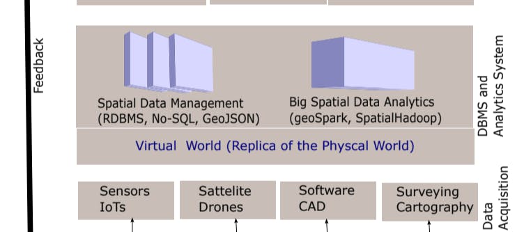
As SDTs need to integrate a vast array of spatial and geolocation data to accurately and comprehensively represent a large physical environment, the scale and complexity of an SDT is much higher than that of a traditional DT. For example, SDTs consist of various form of data that include location data, 3D models, spatial networks, satellite imagery, etc., and to acquire these data we need the support of positioning devices, Internet of Things sensors, drones, satellites, etc. The choice of data sources and categories will be determined by the specific use case and application of the SDTs. [7]. Thus, to build an SDT, we need various spatial technologies. In this paper, we have identified four major building blocks of an SDT and discuss relevant spatial technologies for each of these building blocks (see Figure 2 and Section 3 for details):
-
Data Acquisition and Processing: The first stage in developing an SDT is acquiring and processing data about the physical environment. This can include satellite imagery, LiDAR scans, aerial photography, IoT sensor data, and GIS data, among other forms of spatial and geolocation data. The data must be processed to create a digital representation of the physical environment.
-
Data Modeling, Management, and Processing: This the second layer that models, stores, and provide data management and processing platform for spatial data. This include modeling different data types such as location, 3D, image, etc., and provide data management and processing platform such as PostgreSQL, geoSpark, etc.
-
GIS Software, Maps, and APIs: This middle layer contains GIS platforms and base maps, and available APIs to perform different operations on spatial data. This layer fetches the data from the previous layer and fusion it with maps, GIS, or 3D platform software.
-
Key Functional Components: This final layer involves key functionalities that include simulation, predictive modeling, visualization, query processing, etc. To provide these functionalities, an SDT need the support the spatial technologies of previous layers, and other supportive technologies like AI &ML, block-chain, etc.
1.4. Scope of This Work and Contributions
Most of the existing works related to SDTs highlight different application areas and use cases of live city digital twins (e.g., [8, 9, 10, 4, 11]). A recent work [12] lists a number of city digital twins and discusses commercial software tools for building 3D city digital twins, which include ArcGIS by ESRI [13], Azure Digital Twins platform by Microsoft [14], 3DEXPERIENCE platform by Dassault Systemes [15], etc. Our paper is orthogonal to these software systems as we focus on key spatial technologies that can be used to build an SDT, and these software systems can also be used as a base with other spatial technologies for a quick development of SDTs. In particular, in this paper, we primarily focus on summarizing and analyzing various spatial technologies including spatial data management system, big data analytic system, GIS software, APIs & Tools, etc., to develop an SDT, and highlight the potential future works in this domain. The key contributions of this paper are as follows.
• We highlight the potential differences between SDTs and traditional DTs, and also identify key application areas of SDTs.
• We are the first to propose a layered framework to identify and categorize existing spatial technologies and map them to different layers of building blocks of SDTs.
• We analyze the roles of emerging technologies such as AI/ML, blockchain, and cloud computing in the context of SDTs
• Finally, we identify a number challenges and potential future research directions to guide researchers and practitioners working on SDTs.
The rest of the paper is organized as follows. Section 2 presents related work and case studies for some real-world spatial digital twins. Building blocks of SDTs are discussed in Section 3. In Section 4, role of other relevant technologies such as AI/ML, blockchain and cloud computing in SDTs is discussed. Section 5 discusses some key challenges and opportunities in this area. The paper is concluded in Section 6.
Authors:
(1) Mohammed Eunus Ali, Department of Computer Science and Engineering, Bangladesh University of Engineering and Technology, ECE Building, Dhaka, 1000, Bangladesh;
(2) Muhammad Aamir Cheema, Faculty of Information Technology, Monash University, 20 Exhibition Walk, Clayton, 3164, VIC, Australia;
(3) Tanzima Hashem, Department of Computer Science and Engineering, Bangladesh University of Engineering and Technology, ECE Building, Dhaka, 1000, Bangladesh;
(4) Anwaar Ulhaq, School of Computing, Charles Sturt University, Port Macquarie, 2444, NSW, Australia;
(5) Muhammad Ali Babar, School of Computer and Mathematical Sciences, The University of Adelaide, Adelaide, 5005, SA, Australia.


