
The maps have been, are being and will be, a key piece in the history of mankind. The cartographers have been emerging the land of our planet, a silhouette that has changed over the centuries and with Europe and Asia as the undisputed protagonists in the cartography. However, from the 16th century, the obsession changed to the west: now we wanted to map America.
500 years earlier, Nordic explorers have already stepped on the American continent, reaching the coasts of what is now Canada and part of the United States and capturing their vision on a map. This Viking document perfectly reflects that ‘perfection’ of the European silhouette and the sketch, or La Mancha, which was the American continent.
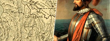
And, among all the incipient maps of America, the most intriguing is that of Piri Reis. The reason is that It is very precise for its time And the author said he was based on lost maps, supposedly, drawn by Christopher Columbus.

The mysterious Piri Reis map
In the era of discoveries, explorers such as Columbus, Magallanes or Vasco da Gama found their best ally on the maps. They helped cross the oceans, but as they did, they were capturing their vision of the ‘New World’ in maps to help in the planning of future expeditions.

The map of Juan de la Costa de 1500 is considered the first that includes a representation of America. It has important accurate, but it is the only one made by a witness of the first two trips of Columbus and the terrestrial profile, unequivocally and despite errors, it is America. A few years later, in 1507, the enigmatic map of Waldseemüller arrived, in which the name “America” was used for the first time.
Again, there were errors in the profile of the Eastern coast of South America, but these two explorers were not the only ones who mapped the continent at this time. In 1513, the Ottoman Piri Reis not only mapped the same territory, but did it with a past accuracy and detailing territories that should not be there (because they had not been discovered).
On this map, we find the following:
- The east coast of South America to Argentine Patagonia.
- The Falkland Islands.
- Antarctica

Here are several details that surprise and invite you to lift an eyebrow. Piri Reis was a admiral and cartographer who, from a young age, participated in several battles in the Mediterranean, cartographing the territory and its islands. However, in 1501, only nine years after the discovery of America, his uncle and captain Kemal Reis of the Ottoman fleet captured several Spanish ships near the Spanish coast.
Questioning the crew and looting the ships, discovered that one of them had been in the New World during Columbus’s journey and had a map drawn by himself that represented the American profile. As he was not a cartographer, he took it to Piri to study it.
Thus, the cartographer got to work and, having as a source that map of Columbus, other Portuguese maps and several letters, began in 1511 to design its map. He did it on gazelle skin and surprises that Piri, really, did not travel to the New World, but that he drew everything based on the sources that had gone to an expedition. As well as knowledge of Ptolemaic Mapamundis.
The most controversial of the matter? To start, the Falklands. As many times throughout our history, the discovery of the islands has several boyfriends. Numerous maps after 1520 suggest that the Malvinas were first sighted by Magallanes, but Portugal also wants merit and attributes it to Américo Vespucio’s trip of 1504.
In the map of Waldseemüller the islands are already intuited, but it is in the Piri Reis that are represented in a much more faithful way to reality. Identified as ‘Il de Sare’, the islands have compared with the Malvinas, located east of the Magallanes Strait. The Horn of Argentina is more stretched than it should, also the Caribbean, but surprises how well represented the entire eastern area of the continent is.

Creatures … strange
On the other hand, and the strangest thing is Antarctica. The first thing is that it is represented without ice, something impossible, since it has been covered by that white mantle. The second is that, officially, it was discovered in 1820.
Apart from this, the cartographer made some descriptions of some of the areas and represented both animals and mythological creatures, something normal at the time.
Chiripa and pombo polemic
For years, Piri Reis’s map was in the shadow. However, in 1929, a group of scholars had the commission of organizing the archives of the Topkapi Palace in Istanbul. The idea was to turn the palace into a museum, so you had to clean the basements and classify everything found.

On a wall of the Ottoman Empire section, hidden and forgotten, the director of the national museums, Halid Edhem, found the map. Due to the mentions of Fuentes such as Cristóbal Columbus as it represented unknown details for the Ottomans of the early 16th century, the map was studied almost from the first moment.
It is a Turkish national pride since 1933, but there is a problem: although it has extremely well represented areas, others, such as Stretched Caribbean Islands or the Union of Argentina with Antarcticaadded to the intrigue to know how an Ottoman who did not travel to a new world that, when the map was made, was in an extremely early phase of exploration, have raised controversy over the years.

The most accepted theory about the map profile. There are those who say that Argentina’s horn is an error of the maps of the time, but also that having run out of space to draw would have motivated that elongated form
Theories have been generated on the existence of ancient civilizations with advanced cartography abilities -controlled and without foundation. This may be because, although Piri cited reliable sources, he also referred to the “former kings of the sea.” But, above all, the main controversy is that certain parts of the map seem made from aerial perspectives, something impossible.
The year China discovered the world and Columbus’s legacy
The truth is that the map continues to bring many researchers head. Among all the sources that Piri used to make his famous map, other theories point out that one of them could have been China. That of Admiral Zheng that would have reached the Pacific coast of America about 60 years before Columbus. In 1421, specifically.
But well, controversies and fountains apart, because beyond the Falklands or Antarctica, the island is also discovered that was discovered decades after the elaboration of the map, the Andes or the birth of the Amazon, all unexplored at that time, that of Piri Reis is a spectacular work and of great cultural importance.
The reason? It is the best testimony of that lost map of Christopher Columbus. There are inaccuracies, yes, but it is also remarkably precise in some areas and, as we say, it is considered one of the best testimonies of Columbus drawn maps, of which only a small sketch of the north of the Spanish island is preserved.

Taking into account the elongated form of the island on the map of Piri Reis and the three towers that the Ottoman represents and that was also on the map of Columbus, as well as names of some ports reflected in the Colombian texts, this map serves to have an idea of how Columbus reflected America on its first trips.
Currently, the map is in the Topkapi Sarayi Museum in Istanbul, but is tremendously fragile and, therefore, is not commonly exhibited to the public. It continues to study, but in this case, it is through high resolution reproductions and images because, as we said, beyond its precision, it is a perfect compendium of the information available on America at the beginning of the 16th century.
Images | Yair Haklai, Robert Jones.
In WorldOfSoftware | The Google Maps of submarine cables: an imposing interactive map that allows us to know the skeleton of the modern world


