
Mexico City is one of the most populated cities in the world, also one of the most stuck cities in the world. There were no roads ago, but channels: an intricate network that were the arteries of Tlatelolco and Tenochtitlan. The two Mexican cities used to browse themselves culturally and trade until they joined in one.
Thus, Tenochtitlán was one of the most powerful and large cities of his time, with a very careful structure of neighborhoods, the aforementioned system of channels and a network of channels and bridges that connected the different parts of the city. For 1518, less than 200 years after its foundation, Tenochtitlan was an imposing metropolis.
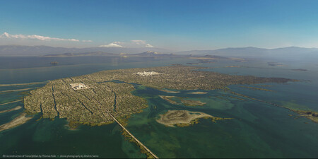
The big question is … What was Tenochtitlan at its peak? It is a question with a complex answer, but the good news is that there are some maps that allow us to get an idea. After the occasional artistic representation of the city, the best portrait of Mexico-Tenochtitlán of that 1518 is that prepared by Thomas Kole.
Tenochtitlan in all his glory
Kole is a 3D artist who, together with a fortnight of collaborators and numerous sources, rebuilt the Mexican city at its time of splendor. All the images of this article are Kole’s work. There are also a series of aerial photographs, taken with Dron by Andrés Semo García, which allow to compare more clearly of Mexico City with the former Tenochtitlan.
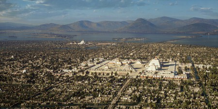
3D recreation of Thomas Kole
Tenochtitlan was, above all, a masterpiece of engineering and hydraulic. We have already commented that the channels were the arteries of the city, and it is not for less because they allowed not only the transport of people, but also of goods.
Through canoes that had great maneuverability, they could transport food and objects, but the port was also a cultural center where merchants from different regions gathered.

Apart from the channels, they developed an advanced water management system with aqueducts that supplied fresh water to any point in the city. The main one was that of Chapultepec, with a double pipe system that distributed water more efficiently. In an engineering display, they also had chinampas, floating gardens or orchards to maximize agricultural production.
The Mexica was a highly stratified society in which the different social steps were very clear. It was very similar to other civilizations and, comparing with one that catches us close in Europe, we could relate them to the feudal system.
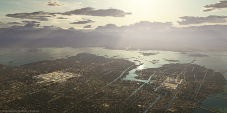
3D recreation of Thomas Kole
The elite was made up of a high class in charge of administering the empire, a nobility with religious and military positions, and the merchants, who occupied a privileged place for their strategic role.
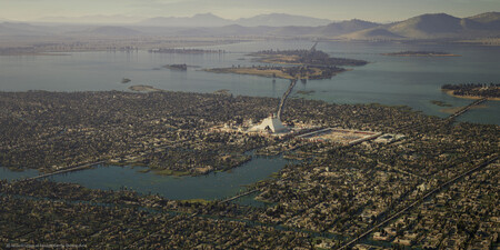
3D recreation of Thomas Kole
Then there was the ‘common’ class with farmers, warriors or artisans and, above, the Huey Tlatoani, the cusp of the pyramid. He was the greatest ruling both military and religious. Moctezuma was one of them, without going any further. Moctezuma II … too.
Of the peak to the fall
In its maximum splendor, Tenochtlitlán had about 200,000 inhabitants. To put it in perspective, Paris had about 150,000 inhabitants at that time, London about 60,000 and Rome just 50,000. Bad example of Rome, since they were recovering at that time, but hey, the point is that the Mexican city was much larger than the European cities of the time.
3D recreation of Thomas Kole
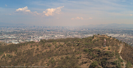
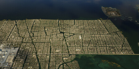
Photograph by Andrés Semo García (Semodron)
Three years after that splendor … Hernán Cortés arrived. The Spanish conquering troops, with the native help that was under the yoke of the Mexicans, took Tenochtlitlán. The centuries passed, the old Mexican culture and rites were buried and, from the ruins of the great Mexican city, today’s city emerged.
3D recreation of Thomas Kole
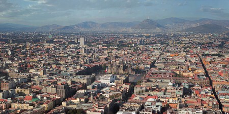
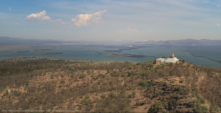
Photograph by Andrés Semo García (Semodron)
As Kole points out, and as can be seen in the city, after the Spanish conquest there was little left of that Mexican past. From time to time, remains of channels and other archaeological vestiges are discovered, but the best way to take a look at how the great Tenochtlitlán could be is through works such as this artist.
3D recreation of Thomas Kole
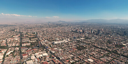
Not even the same zone | Photograph by Andrés Semo García (Semodron)
Also thanks to the photographs with drone about which Kole imagined the Mexican city and allows us to see that some of the current great avenues could be in the past some of the most important channels in the city. The lake was dried and the city, which was once great and is now huge, has gained ground to nature in a surprising way.
In this article we have left some of the most shocking images, but to better appreciate Kole’s work with more direct comparisons, we recommend visiting its website on this link.
Images | Tenochtitlán portrait
In WorldOfSoftware | Everyone knows Teotihuacán, and it turns out that in another inhospitable area of Mexico there were hidden pyramids


