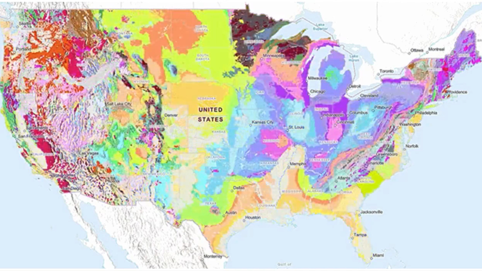
In what the agency hopes will spur a major leap in American geoscience, the U.S. Geological Survey has released a new mapping tool that allows anyone to peer into the earth beneath their feet. Dubbed The Cooperative National Geological Map, the new application collates over 100 geological maps of the lower 48 states to form the first geological tool of its kind to operate on a national level. Designed for educational, industrial, and governmental uses, the free, publicly available site is very user-friendly and is expected to serve as a valuable research tool for hobbyists, educators, and geologists alike.
In providing such a tool, the USGS hopes to impact the various scientific, industrial, and public safety questions whose answers lie deep within American soil. Geological mapping is a critical for exploring some of the world’s most ancient questions, ranging from the origins of life on Earth to how a collision with the celestial body Theia formed the moon. But the uses of geological maps go far beyond the scientifically esoteric, since the data displayed in the USGS’s new tool is essential to solving several economic, energy, public safety, and infrastructure questions facing U.S. lawmakers and citizens. As such, the new tool could prove critical to boosting the country’s disaster preparedness, real estate development, water planning, and mineral exploration efforts, among other concerns.
How to use the USGS’s new map
To access the new tool, users can visit the Cooperative National Geological Map website. Both desktop and mobile-friendly, the application is completely free and requires no personal information or login credentials to get started. Additional tools and information can also be found at the USGS’s National Geological Map Database, while underlying data can be accessed through its catalog.
The map is a useful tool for a variety of users, ranging from classrooms, city planners, government agencies, and water utility companies. With a straightforward interface, an in-depth help guide, explanatory notes, and even a search function, the map is suitable for all ages and expertise levels, although younger students may take time to synthesize the data they are encountering. Divided into four geological map layer selectors — Earth Surface, Quaternary, Pre-Quaternary, and Precambrian — users can filter results based on the geological layer. These subsets are incredibly helpful for geological studies, allowing users to choose the specific geological features, material types, or time periods to study.
For instance, the Earth Surface layer shows the nation’s topmost geologic topography, while the Precambrian period reveals the “basement” rock with units extending to the Earth’s Paleozoic era. The tool also allows users to change the style of the map’s units, providing greater control over how information is displayed. Additional filters allow geologists to perform more refined searches, while a helpful sidebar displays information such as geological age, geological material, source geology, and even a bibliography for the current data set.
Mapping the road to progress
The map constitutes a major leap in the USGS’s ability to share and accumulate information. These advancements are exemplified by the speed with which the database was created, as automated tools to combine regional, state, and national geological survey maps enabled the organization to build its application in only three years. According to Sam Johnstone, the USGS’s lead developer on the project, previous maps took decades to create. This process allow USGS to update its maps as local organizations continue to develop their understanding of geological landscapes, quickly incorporating discoveries into the databases’ mapping system.
USGS leaders believe the new map could deliver a major economic windfall for its users. According to a recent American Geosciences Institute study cited in the USGS’s press release, geological maps crafted between 1994 and 2019 delivered economic benefits at 10 times the cost of their creation.
In the agency’s press release announcing the new tool, Christopher Swezey, the project’s coordinator, stated that the map will help users accomplish a variety of tasks, such as “helping experts look for energy, mineral and water resources.” Swezey also noted that it could be used to “assess earthquake risks and inform decisions about land use, infrastructure and community planning, and real estate and insurance.” These uses highlight the importance of the USGS’s efforts to expand the map’s data and functionalities. Plans to extend the tool to cover Alaska, Hawaii, and the U.S. territories are in the offing, while the agency’s partners look to continue to add to its dataset. Whether they’re researchers discovering new minerals vital to the economy or tracking the explosions of underwater volcanoes, you can be sure that geologists will be using the newest mapping tools to help them explore our planet’s most pressing questions.


